Wednesday, May 18, 2022

Directional signage Redstone trail

Note: This is a DRAFT version last updated 2022 05-18. 

For comments, suggestions or more details contact:


Bob Cottrell, Curator
Conway Public Library's Henney History Room
603-447-5552 
cell phone 603-323-3359 

possible "logo" image to use on trail (like the one on Swenson's rock) signs with graphic designer color scheme.

x


detail 

x


click on images to enlarge them
right click on images to save them to your computer 


The interpretive signs start with a welcome sign near this kiosk is at the western end of the trail 


continue on the trail past the sign 


x


x
directional sign A  goes here to direct visitors across the railroad tracks on to turn right and follow along the tracks for a while


directional sign B where trail turns left and heads into the woods


x


once into this part of the trail There are a number of potentially confusing twists and turns here. 

x
directional sign C is located where the trail crosses the old railroad bed and we don't want visitors to get lost here 

x


x
x


x

directional sign D corresponds with NEMBA sign #39 and our sign would direct visitors to the "pillar" to the right and the interpretive sign there. 


x


x
directional sign E, 4 corners, 
leads right to the carpenter shop, left to the lathe house and quarry 
x


4 corners,  intersection 
you will find NEMBA post number 41.
take a left here 


See the post #41 behind the person 


x


directing you to the Swenson trail and the outer limits trail to the right
other directional signs can be found on the trees themselves. 


x

directional sign F
intersection, 4 way cross roads 


another view of the 4 way 


x


x

follow this curving path up the hill to the Green quarry 


after exploring the green quarry return to directional sign F
then left to sign G
x


x
directional sign G 
straight into the red quarry (where Deb going) or right downhill back to the lathe house 
and directional sign E


x


x
Directional sign H
note if continue to red quarry, come to dead end, turn back to this intersection to head down to main trail 


x

Then re-trace your steps and come back to the T and continue on what would have been the left path at the large stone 
after exploring the redstone debris, return to directional sign G
right downhill back to the lathe house and directional sign E 


x

back down to directional sign E

x

x


Just down the road to the left are the remains of the carpenter shop (interpretive sign 6).  


Just a short distance away 
on the other side of the 4 corners,  intersection 
you will find NEMBA post number 41.
take a left here 


See the post #41 behind the person 


x


directing you to the Swenson trail and the outer limits trail to the right
past interpretive sign 8 for the site of the office. 


follow the path through these large concrete blocks. 
Directional sign "I" here 
x

x
follow the path to the right 


x
to the end of the trail 

Eastern entrance gate


from here follow the trail back to the Hemlock parking area, 
or go south on Mountain Street and right on Redstone and follow the old rr track bed to the Hemlock parking area. 


z

Monday, January 31, 2022

010 welcome west end qr code redstone

x
This kiosk is at the western end of the trail 


insert main logo here and/or image of kiosk 


Welcome to the Redstone Quarry Trail

ghi
the trail is x mile/s long and should take about x time for round trip tour
  

Theclio, QR code on each sign allows you to further explore each station, stop on the trail.


Observe, question, comment, we would love your input, option to do a survey

Add to the log, the weather, good, bad experiences, etc. questions, suggestions, this is your trail, …


Short distance from here cross railroad tracks, be careful, they are still active/operated tracks, trains run on them, fmi on trains, Conway Scenic Railroad in North Conway

History of how the railroad led to the quarry

after crossing the train tracks, follow directional signage

x

what this pipe for? 


need a directional sign here to the crossing on the right


Turn left at the "alien" concrete barrier 


cross the rr tracks here 


be sure to check for the train. This is an active train line. 
If it is clear, look at the details of the raised letters on the rails. 


what kind of permission do we need to have folks cross the railroad tracks? 
perhaps some kind of ramp system? 
need a directional sign here to the left 

look closely on the rails for raised lettering 
also look at the various parts of the rail system 
insert pics of each 


an interpretive sign or qr code to a webpage could related the relationship of the railroad to the development of the quarry, see Hounsell, pp. 193+

"In 1880, the attention of George W. Wagg was called to the fine quality of granite which was used in some bridges of Conway." 

copy more from Hounsell p. 195 use this instead? or in addition? 

"Somewhere between 1876 and 1880, there arose a need for stone abutments for three bridges in Conway... They were made of granite boulders lying handily at the foot of Rattlesnake Mountain. The ease with which this stone was split and handled excited the admiration of the stonecutters and it was not long before this came to the attention of George W. Wagg, general roadmaster for the Maine Central Railroad. He saw great possibilities in the stone because of its color and the fine luster it would take, too." 


then map navigation, but also community, it is a memory map drawn by A.J. "Babe" Pennette.  (check spelling, ask Ken Rancourt for more info on this). 

The image below is a hand drawn map of the area. It can help you navigate through Redstone village and understand the industrial areas on the trail. 


insert photos here of the path from the train crossing to sign #39

There are a number of potentially confusing twists and turns here. 

x


x


Directional post #39. Follow the arrow that leads "To Hemlock" 

can we make this section of trail more straight here? it is kind of confusing when crossing Redstone street on the way to the railroad crossing. 

see  trailforks map pillar to pond link here


next stop will be engaged column look for this (insert image) 


x


x

Credit for swenson, russack, cottrell, hhr, chs, etc. 


Also a link and  qr code to the survey here? Or? 

xyz


yzx

100 welcome sign east end qr code redstone

Welcome to the Redstone Quarry Trail (east end) 

the trail is x mile/s long and should take about x time for round trip tour

Eastern entrance gate


Walk around the gate. Be sure to carefully read the signs. 
what are rules of parking here? 

next stop will be (insert image)

x
School 


two room school, steam whistle 

location of church 


info on Redstone Church from Hounsell, 196, 
small non-denominational church built by I.C. Pert. 

insert here about the houses and street names 

train tracks 


This sidetrack was a  second set of railroad tracks was covered with asphalt leading into the trees on both sides


notice the cracks in the asphalt under which the train tracks are covered. 
This was the "side track" or siding where train cars could be set aside so as not to stop the regular train traffic on the main line.  


Credit for swenson, russack, cottrell, hhr, chs, etc.


Also a link and qr code to the survey here? Or?

xyz

090 tumbler site and office qr code redstone

abc


ghi

Here is a photo showing the concrete structure and the rock tumbler before it was stolen. From the website here and the webpage here. (This Rock Tumbler was stolen out of the quarry in 2010 for scrap metal. Photo courtesy Stephen Thomas collection). need to get permission to use this photo. 


Joe Viger photo of stolen tumbler 

Here is a picture of how the office used to look 


insert picture of it from the inside too. 

xyz

080 carpenter shop qr code redstone

abc


Just down the road to the left are the remains of the carpenter shop.  


This building should probably be boarded up or removed for safety reasons. 


ghi


xyz

070 quarry site qr code

abc


derrick and its "bull wheel" wetland protection, conservation 


x
Green quarry, full of ground water, at the top of the one-way, winch rail line. Remnants remain of three wooden derricks, an engine house and "tugger" winch (1893) which retracted a rail car from the end of an extensive quarry dump. Parts of two derricks are obvious within the quarry hole while the third, "stiff-leg" derrick was higher up in the back SE corner of the quarry. When viewing the latter remnants one may note an excellent example of a "clovis" arrangement of hardware which is the anchor for a guy-wire attached  to the top of a derrick.


ghi


xyz

060 lathe house qr code

abc


x

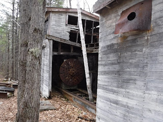
Now let's look at the lathe inside the building. 


How it worked 
Note: The sundial at the east entrance and the pilaster near the west entrance were turned on this lathe. 

A tree has grown in the middle of the lathe cradle. Should we cut it? 


x


x
leather belts were connected to the drive above. 


Some of these belts may have been made at Page Belting Company in Concord, NH. Tie to NHDCR info if they have it. As of 2021 the company is still in business. See this link here


It was made by the Betts Machine Co. in Wilmington, Delaware 


which photo looks better on a cell phone? click on images to enlarge them.  


For more on this company see this link here


There is a second lathe outside. 


knuckle joints 


How to explain these gears and gizmos? 


option A take the wider road up


x

This is the 


ghi


xyz