NOTE: This is a rough draft. I welcome any comments or suggestions.

While this blog post is about rock, it is not directly related to Led Zeppelin's song "Ramble On" with its reference to J.R.R. Tolkien's Mordor. However, another rock star does play a role in the story below.
The photo above from around 1860 by the world famous Bierstadt brothers is from the Nelson Atkins Museum of Art and featured in the book East of the Mississippi available at the library. For more on this photo see this link here.
Below is a nearly identical view from a post card from around fifty years later by a local artist, how it looked when it was a popular tourist attraction with religious connotations. It is from a post card labeled at the bottom The Cathedral, North Conway, N.H. Pease, North Conway, N.H. Copyrighted 1909 by N. Weston Pease, North Conway, N.H. 2095.

When local historian and educator Brian Wiggin recently posted this image on Facebook it received 88 likes and 53 comments including personal experiences and community associations not found in academic studies on the subject. Here are a few examples,
My grandmother told me the following story: "There once was an old pump organ placed inside one of the caves and several couples got married there. Hence Cathedral."
Also the old-timers remember that Cathedral was a local make out spot.
I don't mind sharing that we often drove up the rutty dirt road to party at the top...cops wouldn't drive their cars up that road...no houses at the bottom...just blueberries !
It was THE best place to pick wild blueberries locally . We once took a young relative from Ohio to pick there and she stood in the middle of the area looking up to the sky. My mother asked her ,"What is wrong?" Her response, "I am looking for the blueberry trees." Oh my - what a laugh we had.
Originally it was called Hart's Ledge. The family of Hart is buried in likely the worst kept cemetery in Conway - simply a family plot on the back road to Echo Lake relatively close to the road leading to Cathedral today. Some have no writing on them and there are simple rocks also to mark the place of a deceased. That road next to Echo Lake was the original road to Canada.
There were absolutely no houses at its base - today there may be one hundred.
Today it is still a very popular spot, but not for its traditional amorous, celebratory or theological reasons. Today it is known for it's fifty foot 5.11 to 5.13 "very strenuous" bolt protected sport routes.
That perspective is from the rock crowd, rock climbers that is. More on that topic later.
It is interesting to trace the continuity and change over time of how a place is "viewed" while the actual physical character of the place has not changed that much (as seen in the photo comparisons above).
To help us trace the trail let's go back in time and into the third dimension and do a virtual ramble over the river and through the woods.
Grab your historic stereo viewer, (or borrow one from the library).


Designed by the legendary Brian May, astrophysicist and lead guitarist for the rock band Queen, the OWL viewers can be purchased through his London Stereoscopic Company at his website here.
There are a number of options including the limited edition "steampunk" OWL, the "lite" OWL, and a VR kit that has a specialized smart phone adaptor.
If you decide to gear up for the stereo view sensation, you can find an ever growing online library of local stereo views here and a winter on Mount Washington from over 150 years ago here.
Below is a Bierstadt brothers stereo view of the Cathedral.

This one is from their 1878 book Gems of American Scenery. for a draft version of this follow this link here. Notice the person standing by the tree for scale.
This book had a stereo viewer built into the cover.
There is a copy of this book at the New Hampshire Historical Society.

It came complete with instructions.


The stereo view below is by the very same N.W. Pease local photographer, who did the post card above. More more on Pease for more on him see link here.

The one below from Littleton NH photographer Kilburn brothers. They were one of the largest producers of stereo views See more here.

Let's compare these stereo views again with the photo I took recently.

If you want to visit, see this in real life, I recommend starting at the Intervale Scenic Vista here.


A roadside marker outside of the visitor center acknowledges the role of the area in the development of the so-called "White Mountain School of Art."
From this point, you can see a panorama vista, that encompasses much of the valley and mountains beyond, a view similar to this painting by Albert Bierstadt from around 1862.

You can learn more about the painting here. fmi on this view see my article "Patterns in the Landscape" in Beyond the Notches, pp. 103-108, where I cover the role played by settlement history trends, folklore, fire, soils, plants, ecology, history, geology, agricultural history, floods, hydrology, in shaping this view. see scan and post link to archive org and/or expand on it with my old notes
Bierstadt is known to have used photography as a way to record a scene to help with his painting. Compare the photo below with the painting above.

For more on this photo see this link here. From this vantage point, you can see how the classic iconic "sheep back" shaped ledges known in French as "roche moutonnee" For more information see this link.

The characteristic rock cliffs that we see are the results of glacial polishing and plucking and ongoing freeze and thaw cycles.
insert map from the echo, rambler map
insert map hotels intervale
and the book getting from the hotels in Intervale to the cathedral was an adventure in itself
there was a ferry, then a floating bridge then ferry? more on this from Aileen M. Carroll's The Latchstring Was Always Out available at the library. pp. 76-78, also Hounsell, Emerson, etc.


for more on this bridge see this link here.
also see reporter news

guidebooks talk about buckboards like the one depicted above

The prow was the subject of a number of paintings by other later artists such as Daniel Huntington in 1854. For details on this sketch see this link here.

Local artist Benjamin Champney

fmi on this painting see this link.

The bottom section of a painting at the New Hampshire Historical Society by Thomas Hill will be explored later when we address the Devil's Den. found meaning in the pattern of these jumbled, rocks, rock piles, pile of rocks

Asher B. Durand did two paintings of Cathedral Ledge. One can be found at the Albany Institute here.

Asher B. Durand did two paintings of Cathedral Ledge. One can be found at the Albany Institute here.
Asher B. Durand at the Albany Institute of Art link here.

While Durand's paintings are from slightly different angles than the images above many of the details are relatively easy to match up with Peg Immel's 1993 poster from our previous blog here.
Another Asher B. Durand, in a private collection, includes an artist sketching with a well dressed lady admiring the view. This image can be found on the White Mountain Art website here.

You can see more about that painting at this link here.
Fmi on wma com other views of Cathedral Ledge see this link here.
In all these paintings you can see the results of ongoing action freeze and thaw cycle.
insert rock fall, talus slope here or elsewhere? maybe with bierstadt currier
when do that be sure to compare currier photo bierstadt with painting
to better understand what is going on here geologically let's go back around 10,000 years ago when this area was covered by glaciers
talus cone
insert talus stuff here? instead of elsewhere
The characteristic rock formation that we see here ongoing freeze and thaw cycles.
insert rock fall, talus slope here or elsewhere? maybe with bierstadt currier
when do that be sure to compare currier photo bierstadt with painting
to better understand what is going on here geologically let's go back around 10,000 years ago when this area was covered by glaciers.

note the "farthest fallen block" it below.


exceptional photo Plymouth State University's Museum of the White Mountains.

Below is a cropped version edited for brightness and contrast to better view the features and details.

A detail of the bottom of this photo shows from left to right, a horse drawn mountain wagon, a set of stairs, a shed of some sort, the opening to the Devil's Den, a man in a pith helmet, a camera on a tripod, a ladder, and another man in a pith helmet (click on images to enlarge them).

The person sitting on top of the large rock above the opening to the Devil's Den shows the sense of scale.
Thomas Hill see this link here.
The bottom section of a painting at the New Hampshire Historical Society by Thomas Hill matches up quite well with the photo above.
As a reminder, here is the entire painting.

As a reminder, here is the entire painting.

Winslow Homer mountain wagon?
Devil's Den, exterior hart's ledge here. Pease

notice the person sitting on top of the rock above the opening.
Below is another Pease, showing a view from inside the Devil's Den interior here.

In 1887, Winfield S. Nevins explains that a "Hermit Hapgood" would lead
you into the Devil's Den with a pitch-pine or smoky birch-bark torch.
You can read about it here. In his 1942 recollections, George Russell relates a similar story about the hermit. You can read about it here.
Each generation has a different sense of value, adventure
theologian, geologist,
where one sees cathedral, another sees devil, a geologist sees a talus cone
a winter outdoor enthusiast sees a ski jump
1922 talus slope used as a ski jump for the area's first winter carnival
link to reporter news


for more on the "earlier" location of cathedral ledge see this previous blog here.
the talus cone can also be seen in this wonderful work of art by P Immel published by Lewis and Yardley in 1993. available at IME (International Mountain Sports) website.

insert overall if can do of the poster, scan it at staples?
overall

compare to this Huntington

fmi here.


the poster can be matched to a number of books details on the routes such as
Mordor p. x
toponymy study of place names,
poster above place names such as list some crazy ones
according to Robert and Mary Hixon, The Place Names of the White Mountains, p. 35,
attributes appellation to members of a family named Parsons, who visited North Conway prior to 1859, reportedly gave the ledge it present name.
the term Cathedral x
previous name Hart's Ledge
again that facebook post
insert pic cover and map evans
1889 description S.A. Evans here.
title Evans interesting combination attractions tourist and business, balance still a struggle today
for more on evans see this blog here.
Evans involved in what year? not one of 4 custodians, but is listed as a donor,
purchased, protected
for details see Minutes of the Custodians of the Cathedral and White Horse Ledges here.
add about reporter news
from facebook, one of the comments added
x
Late in the season of 1899 it was determined that quarrying of "Cathedral Ledge" would lead to the destruction of the Ledge. In may 1901 there was a movement of lovers of the "Ledge" to prevent the destruction of the Ledge. The owner Richard H. Davis consented to sell it for $1000. No sooner had the securing of Cathedral Ledge was accomplished from destruction by quarrying.
John H. Smith the owner of "White Horse Ledge" offer to sell it for $1500. Donations from citizens from the surrounding towns and visitors mostly from Massachusetts was the fate of both Ledges was achieved.
The Public Subscription and Deeded to the State under a Special Act of the Legislature providing for the preservation of the "Ledges" as "Objects of Scenery" was introduced to the New Hampshire Legistrature under House Bill 344 in 1901 signed by Govenor Chester B. Jordan this way accomplished. Source: White Mountain Reporter May 1901
x
Now NH State Park system
quick virtual visit tour trail guide
as we go along the trail, we will see remnants evidence of rock quarrying
directions

and towering above it all, the prow


insert more trail details here
notice the pile of stones at the bottom, insert geology and ski jump here?

have to final squeeze to reach cave

go to opposite end of the cave to view the iconic scene.

beyond the Cathedral Cave look for seasonal signs Peregrine Falcons


x
return to your vehicle and treat yourself to some strawberry delights, the self serve drive through for jam open year round, in summer tub of strawberries
travel left down x road and see if you can find more Thomas Cole views recorded by Thomas Cole

2nd Cole sketch of the area
add about 3rd cole sketch (here or later near strawberry field?)

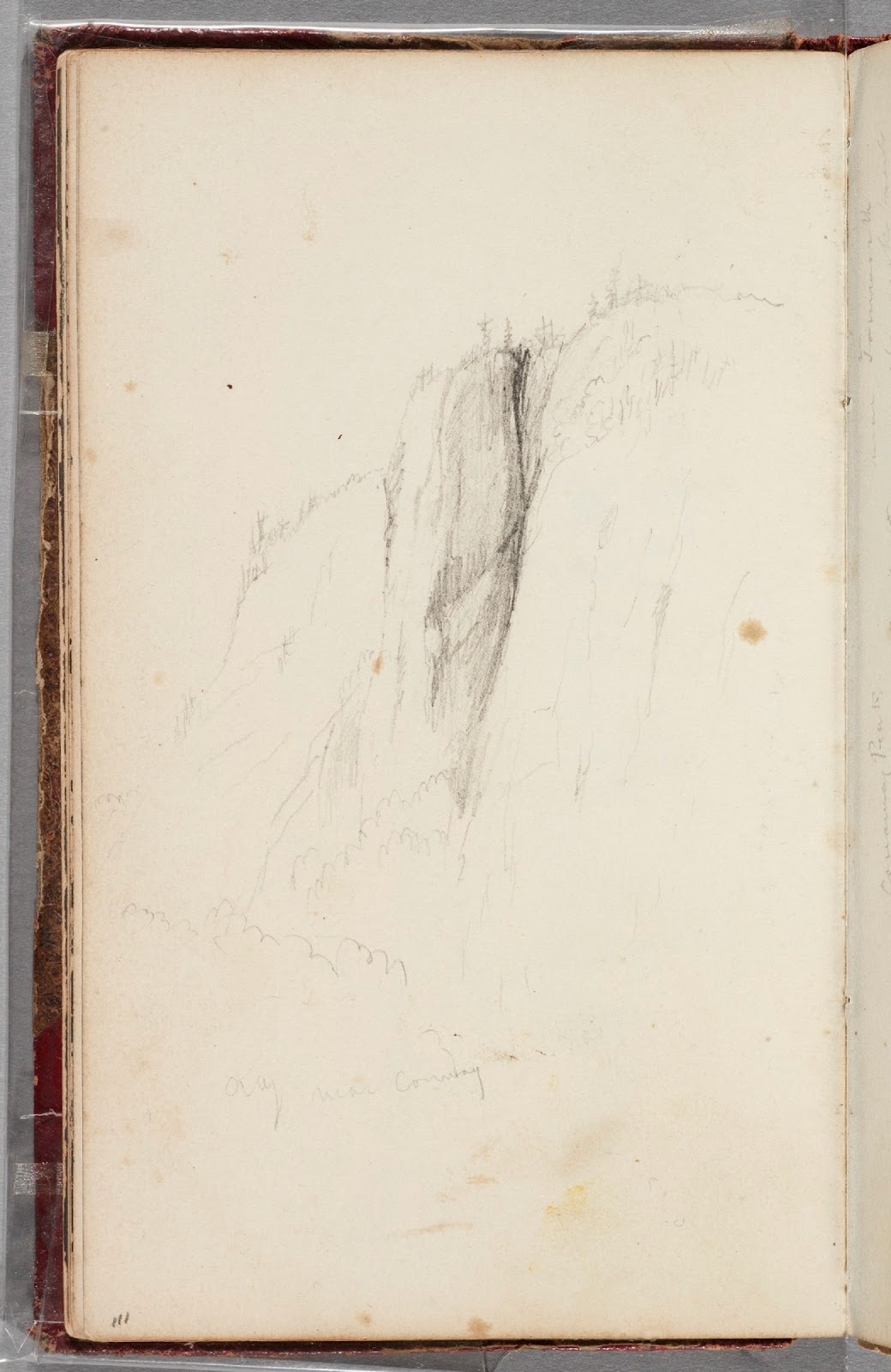
this sketch link here.
notations include mote mountain (now spelled Moat Mountain), Hart's Ledge (now Cathedral Ledge) and flying sunny clouds.
this sketch link here.
notations include mote mountain (now spelled Moat Mountain), Hart's Ledge (now Cathedral Ledge) and flying sunny clouds.
from one great artist to another,
end with a final excursion, diversion into changing attitudes relationship with nature,
geologist, quarry men, artist, rock climbers, newest vision, Jay Philbrick sees a couple ready to "take the leap."

For more on Jay Philbrick's Photography follow this link here.
For more "reel" history and virtual tours see the Conway Public Library's web page here.
This is digital Bob signing off... for now...

... until next time.
No comments:
Post a Comment